Posts

Showing posts with the label sea

Walking the Suffolk Coastal Path - Lowestoft -- Kessingland (Walk 19)

Image
Thursday 22nd August - 4.5 miles. Route taken: Beach, A12.. (Time taken 2.35 hours) Having realised the Walking Men sculptures were only on the beach at Lowestoft until the end of this month (something my husband and I wanted to see), it seemed like an ideal time to cover the above walk for my Voyage award. Our walk started from East Pavilion Point, a Victorian-style glass pavilion. From here we had a look at the harbour entrance, which is very narrow, but can be approached whatever the tide. The Shannon Class Lifeboat is moored just inside the first harbour. We made our way along the promenade. There was much squawking coming from the beach  where a flock of gulls had gathered with their young. Two bird hotels have been built out to sea for nesting kittiwakes. They have been nesting in Lowestoft sine the 1960's. Their numbers had been in decline due to lack of nesting sites and over fishing. Since the hotels have been erected numbers are on the increase once again. The South pier ...

Walking the Suffolk Coastal Path Kessingland to Benacre (Walk 18)

Image
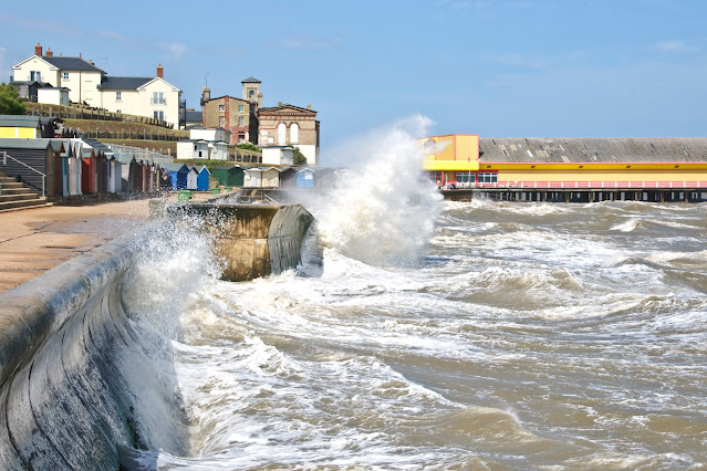
Wednesday 21st August - Distance 2.4 miles Route taken: Beach, shingle and track. Time taken 1.30hrs. Having had a pleasant stay over night at the Hotel Victoria we decided to walk back to where the walking men were to try and take photos while there weren't many people about. There was a total change in the weather today. There was a strong southerly wind blowing and it was much cooler. The wind was whipping up the sand on the beach. I found the beach along this section fascinating with its pristine surface as far as you could see. Time to collect the car and make our way back to Kessingland so I could continue my journey to Benacre. I had delayed the start as long as I could. I wasn't looking forward to walking this section. I would be walking into a strong head wind on uneven ground, on my own. I passed more beach huts as I headed along the coast heading out from Kessingland. A lone hut stood forlorn above the shingle, presumably belonging to a fisherman. Marram grass bent o...

Walking the Suffolk Coastal Path - Shingle Street - Boyton (Walk 5)

Image
(Sunday 31st March - 2.7 miles. Route taken: Sea wall & marshes. Time taken 1hr. 45min) I was looking forward to this section of the walk as I have not walked here before. Unfortunately the weather was not as forecast and there was very heavy cloud and a strong north easterly wind. I found the going tough especially with the very uneven ground. However the wind surfers were having a great time. I felt very alone, just me and my thoughts in this very desolate place. I heard the occasional call of an oystercatcher and a skylark. There were waders in some of the mud flats. I trudged on, battling against the wind.  During World War II the quiet marshes became an area of strategic importance for siting defenses designed to stop a Germany invasion in this part of Suffolk.  July and September 1940, saw 633 pillboxes constructed in Suffolk. Several of these can be seen on the Suffolk Coastal walk. As I walked on I couldn't help thinking about the soldiers who had spent weeks/month...

Walking the |Suffolk Coastal Path - Bawdsey Lane East _ Shingle street (Walk 4)

Image
( Thursday 21st March - 2.2miles. Route taken: Sea wall. Time 1hr.15min) I have walked this part of the route before so am confident of where I am going. It is a warm day but overcast. The path on this part of the route is still very muddy and the track below is still water logged. The coastline around East Lane has, over the centuries, experienced several episodes when defense works became necessary due to the risk of invasion. Recommendations for the defense of Bawdsey were made as early as the sixteenth century. In the early part of the nineteenth century fears of invasion by Napoleon led to the building of seven Martello Towers. During World War II emergency coastal defenses were erected at Bawdsey to prevent invasions from the sea. As I passed the various lagoons on by left I thought I saw the ears of a hare along the track below me. I expected it to have moved before I was near enough to get a photo but it didn't seem to know I was about. I took one photo and then moved forwa...

Action in 2020 - September

Image
Thursday 10th september Walton Walton became popular as a seaside resort during the Victorian era when people were able to travel by train and boat to the destination. There was a decline in its popularity after the second world war. The Naze Naze Beach Huts The Naze Tower, built in 1720, is a historic 86ft navigational tower built to aid shipping.  It  now houses a tea room, art gallery, museum and a roof viewing platform with amazing panoramic views. The Naze Tower Large parts of the Naze have eroded away over the years at a rate of 1 - 2 metres a year.  The pill-boxes from the second world war have fallen from the cliffs and now lay on the beach. Pill-boxes If erosion continues at the same rate it is likely in 50 years time the Naze Tower will be lost to the sea and the Naze might become an island. Cliff Erosion

Action in 2020 January

Image
Monday 13th January Walton The morning was bright but chilly. A good day for a brisk walk along the seafront at Walton-on-the-Naze. There was a fresh breeze but the sun gave off a little warmth. Colours stood out on the beach and symmetrical patterns had been created by the steps that reached up to the beach huts. Sanderlings and Turnstones were keeping busy along the tideline shifting debris in search of seashore invertebrates. Sea defences forming patterns. As the tide came in the clouds began to build and the sea became more turbulent. We didn't hang around as we made our way back to the car.